 |
Mount
Everest
|

On the
morning of May 29th, 1953, New Zealander Edmund Hillary found
himself working his way up a snow-covered mountain. Climbing
with his partner, Tenzing Norgay, Hillary was intently engaged
in cutting a series of steps in the snow to allow them to climb
safely up a ridge. Then, at eleven-thirty, Hillary suddenly
realized there was no place left to climb. "… to my great delight
I realized we were on top of Mount Everest and that the whole
world spread out below us."
On that
day man had finally conquered the tallest peak on the planet.
It was a challenge that had eluded realization even after other
goals, like traveling to the North and South poles, had been
accomplished.
|
Seven
Quick Facts
|
| Height:
29,029 feet (8,848 m) |
| First
Ascent: Edmund Hillary and Tenzing Norgay on May
29th, 1953 |
| Age:
Himalaya Mountains are 25 million years old. Everest
has been the highest peak for the last half million. |
| Discovered:
A British survey of the region discovered it was the
tallest mountain in the world in 1852, but didn't release
this information to the public until1856. |
| Location:
Border of Nepal and The People's Republic of China. |
| Formed
By: An up-thrust at the collision of the Indian and
Eurasian tectonic plates. |
| Other:
Called Qomolangma in China and Sagarmãthã
in Nepal. |
Mt.
Everest is part of the Himalaya Mountains in the central region
of Asia, north of the Indian sub-continent. Three hundred and
twenty-five million years ago the region was the bottom of an
ancient sea. Then, sixty million years ago, the tectonic plate
under India started moving northward and running into the Eurasian
plate. This caused the land at the junction to be crushed and
thrust upward. About twenty-five million years ago this up-thrusting
became the Himalaya Mountains. The lifting of the mountains
continues even today with the range gaining another two-inches
on average, every year. Everest has been the highest peak in
the Himalayas for the last half million years.
Finding
the Height
Although
the Himalayas have long been recognized as some of the tallest
mountains in the world, it wasn't until 1808 when the British
decided to do a trigonometric survey of the region that the
actual height of many of the peaks were established. The project
took a number of years to accomplish and between 1830 and 1843
the effort was led by Sir George Everest, the Surveyor General
of India. The British were frustrated in their attempt to get
precise measurements on many of the highest peaks, however,
because they lay in the country of Nepal. The government there,
suspicious of British motives, turned down all requests for
survey teams to enter the country. This forced the British to
make their observations from as far away as 150 miles (240km)
limiting their accuracy. As early as 1847 the team began to
suspect that a peak beyond one called Kangchenjunga (which was
at the time thought to be the highest in the world) was even
higher, but they could not get precise enough measurements to
be sure.
The
British persevered, however, and in 1852, Radhanath Sikdar,
an Indian mathematician and surveyor with the project, used
data collected the year before to conclude that this new peak,
designated "XV" was the tallest in the world. The announcement
was delayed until, March 1856, while the calculations were checked
and rechecked. The height was determined to be 29,002 feet (8,840
m), though more recent surveys have placed the height at 29,029
feet (8,848 m), not counting the mountain's snowcap.
The
survey team had been directed to use local names for geographic
features whenever possible, but Andrew Waugh, leader of the
survey at the time, stated that there were so many local names
that it would be hard to favor one over another and recommended
it be named for his predecessor, George Everest. The Royal
Geographic Society accepted the name over the objections
of Sir Everest himself. The name is still not universally acknowledged
and the mountain is referred to as Qomolangma in China
and Sagarmãthã
in Nepal. The mountain sits on the border of Nepal and the country
of Tibet (which is currently under the control of the People's
Republic of China).
Ascending
the Mountain
In an
1890 article entitled "Can Mount Everest be Climbed?," mountaineer
Clinton Dent pondered whether this remote peak might ever be
conquered, but the immediate problem with mounting such an attempt
was political, not logistical. The governments concerned, Nepal
and Tibet, rejected all requests to enter the region. In 1913
Captain J.B. Noel disguised himself as a native and entered
the area in an attempt to view the mountain close up, but never
got closer than 40 miles (65km) before he was turned back by
the Tibetan military. Finally, in 1921, Tibet allowed a British
reconnaissance team to work its way up the mountain to the 23,000
foot level. The next year some of the members of the team returned
to make the first attempt on the summit but when an avalanche
killed seven of the porters, the expedition was cancelled.
|

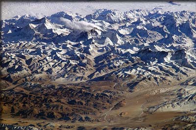
Mount
Everest and the surrounding Himalayas as seen from the
International Space Station.
|
In 1924,
George Mallory, who had been on the first two British expeditions
along with newcomer Sandy Irvine, made an attempt to ascend
to the summit. According to a fellow climber they appeared to
be "going strong for the top" when they disappeared into a mist
of swirling snow. They did not come down and Mallory's frozen
body wasn't found until 1999. When Hillary and Tenzing reached
the top 29 years later they looked for signs that the two climbers
had been there, but found nothing.
Death
Zone
The
pair was just one of many deaths that have occurred on the mountain
through the years. Temperatures on Everest can plummet without
warning,leading to frostbite. Extreme high winds can knock a
climber off the face of the mountain. Because of the high altitude
the air is only about a third of the pressure it is at sea level
making it much more difficult for the human body to get the
oxygen it needs to keep running. Under these conditions a climber
gets tired easily and their thinking can grow fuzzy, making
mountaineering at these heights even more dangerous than it
would be otherwise. For this reason climbers operating above
26,246 feet ( 8,000 m), in what is called the "Death Zone,"
will often use masks that supply them with supplemental oxygen
from a bottle. Hillary and Tenzing used bottled oxygen when
they climbed the peak in 1953 and for many years it was thought
that reaching the summit without it would be impossible. However,
in May of 1978, Reinhold Messner from Italy and Peter Habeler
from Austria made the first ascent without supplemental oxygen,
proving that it could be done.
Hillary
and Tenzing used a path up the mountain called the "Southeast
Ridge" because it allowed access from Nepal. However, in the
years since Chinese policy changed allowing access from Tibet,
a second route, the "Northeast Ridge," has become popular. There
are some thirteen other routes up the mountain, but these are
more difficult and rarely used.
Dangerous
Over-Commercialization
Recently
there have been complaints that the climbing of Everest has
become over-commercialized with more and more novice climbers
hiring professional guides to get them up the mountain. A guided
climb may cost between $40,000 and $80,000 depending on the
route traveled and the client needs little in the way of Alpine
experience. On May 11, 1996, a traffic jam of climbers on one
route, combined with a sudden snowstorm, killed eight people
in one day. Another eight died in the course of that climbing
season, making it the most deadly year on record for the mountain.
Many long-time mountaineers complain that the novices being
guided up Everest do not appreciate the dangerous situation
into which they are placing themselves and they do not have
the skills necessary to save themselves should something go
wrong.
As of
2010, 3,142 different people have reached the summit 5,104 times.
Another 219 have died while trying to climb the mountain. Because
of the difficult conditions on Everest there is often no attempt
to recover the bodies and some frozen corpes can be seen from
the major routes.
Despite
the dangers it seems unlikely that the adventurous will soon
be dissuaded from attempting to conquer the highest mountain
in the world. Why do they do it? Well as George Mallory is often
quoted when he was asked why he wanted to climb Mt. Everest,
"Because it is there."


Copyright
2011 Lee Krystek. All Rights Reserved.